
It was cloudy and kind of cold on the boat ride up Lake Te Anau to Glade Wharf. The wharf sits in a cove at the end of the long lake tucked in with steep mountains making any other form of access very difficult. Glade Wharf marks the beginning of the world famous Milford Track that’s touted as being the finest walk in the world.
The Milford Track stretches a little over 33 miles starting in the Clinton River Valley. It leads up and over Mackinnon Pass and down the Arthur River Valley to Sandfly Point. The track is heavily restricted to 40 independent and 50 guided hikers a day. The independent and guided walkers stay at different huts. Start times and huts are staggered so the independent and guided do not mix. With the independent hikers such as myself staying a little beyond the guided group it’s possible to walk all day without seeing anyone else on the trail. The guided groups start at a set time. Independent hikers do as they wish.
The first day is short and easy. About three miles to Clinton hut. The walk is very nice and passes through thick vibrant green temperate rain forest. Long stringy moss coats trees and ferns. Plants carpet the ground. The first hut is also the first time you really get to meet the other 40 strangers doing the same thing. I immediately hit it off with a couple of women from California who are not only hikers but runners. There was group of Israelis, Chinese, a couple of French, a Canadian, two stylish Korean Women from Gangnam in Seoul and a of course New Zealanders aka Kiwis of the humankind. I also met a young woman from the states who has been living in Australia since her teens. All in all a good group and diverse as expected.
From the Clinton hut the trail climbs gradually upward and the valley narrows. The mountains become very steep and rise almost vertically from the valley floor. The walking is pleasant and becomes more varied and increasingly scenic.
According to the weather forecast I wasn’t expecting things to be too good but conditions on day 2 turned out to be excellent. It was sunny, the temperature was perfect, and there was little if any wind. I took lots of photos and covered the 10 miles or so up to Mintaro Hut with ease.
At Mintaro I stopped, ate lunch, and figured I’d just relax the rest of the day talking to other hikers, however, with the weather so nice it seemed like a good idea to head up Mackinnon Pass which is really the crown jewel of the hike. As I snacked some more, two of the Israeli hikers said they had been reading the Lonely Planet guide and it was advisable to day hike up to Makinnon Pass if the weather is good upon reaching Mintaro. It didn’t take much reasoning to come to that conclusion. One of the Israeli’s commented. “It's the best way”.
Ten minutes later the three of us were headed up the trail. The weather continued with its fabulous display of blue sky and occasional passing cloud. Without packs the hike up felt easy. We met a Japanese man coming down who left earlier to make the pass a day hike as well. It only took us an hour to cover a little over two miles to reach the top.
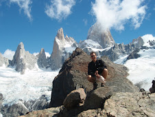
The views were astounding, 360 degrees, all the way around. Mount Balloon with a pointy top sits at the thrown while Mt Elliot and Mt Wilmur host a hanging glacier. The peaks and valleys are extremely steep to vertical. A large monument built in the style of a rock cairn topped with a crucifix marks the pass. It's a memorial for the explorer by the name of Mackinnon who first discovered the region.
With comfortable temperatures and little wind we spent about half hour taking photos and enjoying the views. We had no idea what the weather might be like the following day so we were really happy to have made the decision to hike the pass when we did.
The night was clear and full of stars but colder. The fine weather continued through the morning as everyone headed up the pass with an early start. Although conditions atop were good for a view it was cold, kind of windy, and the morning light was not good for photos. Still, not bad, but not as good as the previous afternoon.
From the top of the pass the trail traverses east to avoid a band of cliffs before descending. The descent was exceeding scenic but a little rugged which made for slower going with a frequent pause to take in the view. At one point the trail goes down a series of steps that are built along a long narrow stream that forms a series of waterfalls and grottos. As if that isn’t enough upon arrival at the valley bottom there’s a side trail that only takes thirty to forty five minutes to reach New Zealand’s highest waterfall, Sutherland Falls. I dopped my pack at a day shelter and took the side trip.
Dumpling Hut was home for night three and the Ranger on sight informed us that a strong storm was on the way. So far, aside of having a difficult time getting a good nights rest at the huts the only annoyance were sandflies. In America we call them black flies. They are small and have a big bite. Their bite emits an anticoagulant that causes a small pool of blood to rise to the skin for feeding. The black flies are much worse in Northeast America so relatively speaking the sandflies in New Zealand are quite manageable and more of an annoyance issue than anything.
Well, on the morning of the 4th day a severe storm blew in around 4 or 5 am and we were told by the ranger not to go anywhere for the time being. Heavy rain, thunder and lightning introduced an enormous amount of rain in a very short period of time. There was talk of us getting flooded in and a possible helicopter evacuation to avoid a section prone to flooding. As the storm raged the walls of the valley turned into walls of waterfalls. The storm blew over Mackinnon pass with gusts up to 135 Km an hour. The front was moving fast. The ranger kept us informed and none of us were too eager to get going. Around 10 am the storm began to ease. Around 10:30 the skies started to show some clearing. The walls of the valley became a spectacular sight with too many waterfalls to mention. Most all were flowing near or full capacity. At 11:15 the ranger received a report that the storm had fully passed and no more rain was expected. We were warned of one section with possibly high water and the ranger said he would run ahead to guide us safely. Had the storm kept raging much longer I think it would have been a real issue. Ironically, it just made things more beautiful.
With waterfalls everywhere I was really happy to walk but even more so just to get the finish the trail properly. There was one flooded section that with the ranger’s advice and direction sent us through knee deep water but nothing really dangerous. The track finishes at Sandfly point which was insanely full of sandflies. By far the worst I’ve seen in New Zealand. I was happy to get on the first boat necessary to cross a body of water to Milford Sound and a bus back to Te Anau.
The Milford Track was definitely a bright spot to my travels in New Zealand considering my issues with Meniere's. Vertigo did rear its uninvited presence a couple of times. The first time was on day two. It was very mild and didn’t last long. I was actually able to walk though it with the aid of my hiking sticks. The second occasion was on the third night as I lay down to sleep. I experienced a fairly intense episode of the spins for a couple of hours as I lay in bed. I wondered if it had something to do with the approaching low of a strong storm.
All things considered I’d say things went about as good or better than expected on the walk, especially considering the weather report prior to leaving. I am really happy that I got an opportunity to hike the Milford Track. It’s a nice little feather in the hat. I was lucky to get a reservation when I just happened to check online as a party of two canceled. On average you have to book a year ahead. When cancellations do pop up they are usually taken within 30 minutes. The Fiordlands of the South Island of New Zealand have to be one of the most beautiful places in the world.


No comments:
Post a Comment